
Information in context
- Project locations and work fronts
- Geospatial records and corridor context
- Aerial imagery when available
Relate field information to corridors, work fronts and physical assets. Spatial context helps teams understand where work is advancing and where constraints need attention.
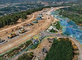
Corridor views, work fronts and imagery can sit alongside progress and constraint information. The right view depends on the project and its available data.
Start with the capabilities your project needs. Extend the system as the information and delivery requirements evolve.

Capture field reality with minimal friction.
Explore Field Intelligence
Connect progress, cost, schedule and constraints.
Explore Project ControlsUnderstand the project in its physical context.
Explore Spatial Intelligence
Turn project information into decision context.
Explore Owner IntelligenceStart with the field reality, information gaps and decisions that matter.